
Showing posts with label Ciudad Perdida Trek. Show all posts
Showing posts with label Ciudad Perdida Trek. Show all posts
Friday, April 20, 2012
Map of Trek to Ciudad Perdida

Thursday, April 19, 2012
Ciudad Perdida, part 4 of 4
COMMENTS ON THE TREK: The Sierra Nevada de Santa Marta is a pyramid shaped mountain range separate from the Andes. They extend over 16,500 square kilometers and are one of the most biodiverse places on the planet. For example, there are more than 650 species of birds living in the Sierra Nevada.
Ciudad Perdida is the ancient Tayrona archaeological site deep in the jungles of the Sierra Nevada de Santa Marta mountain range. The site was discovered by looters in the early 1970's and was finally managed and preserved by ICANH (Instituto Colombiano de Antropologia et Historia) since 1976. Today, the Colombian Military maintains a presence on the site.

To get to Ciudad Perdida, we hiked up and down the steep valleys crossing the Buritaca River several times. It is a three day trek to the site and two days out, although politicians have been known to come in by helicopter. The number of visitors permitted is limited to 100 per day and other than coming in by copter, the trek itself helps to keep the numbers down. The park negotiates with the Kogi tribe to establish a fee and agree to how many people can come through their villages. I hope the Colombian Government together with the determination of the Kogi who believe they are responsible for taking care of the land, that they will preserve the site and not destroy the rainforest in attempts to make Ciudad Perdida more accessible.
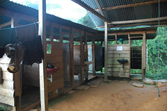
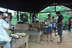
The tour company has everything well organized and provide clean albeit rustic accommodations, hot meals and plenty of fruit and purified water. The cost for the five day trip including transportation to the start of the trail was about $330 Canadian each. they advertise that anyone can do it, but I would say you have to be in reasonably good shape and fairly agile as the trail is sometimes quite steep, with narrow ledges and is want to keep your feet dry you have to jump from stone to stone on some of the river crossings.
One of the highlights of the trek for me was the opportunity to see the Kogi and how they live. They are soft spoken and respectful of each other and of nature. They need very little and don't use anything mechanical. They live off the land but do keep some pigs, chickens and cows. They have plantations of bananas and yucca. They share what they have with other families living at different elevations. I have done some research on the internet on the Kogi and there is surprisingly little information available. And what is available is sometimes contradictory. Even though they would stop by our camps, they didn't interact with the hikers, only with the guides. And even then, it was just a greeting and sharing a few moments together.
Ciudad Perdida, part 3
THE ANCIENT CITY - CIUDAD PERDIDA

It is the fourth day of our trek through the Sierra Nevada rainforest. We arrived at the last camp on the trail late yesterday morning and the rain started just after lunch. We delay the final climb to the site until the next morning when the rain will have stopped and the sun will be out. This deep in the mountains, we have had rain every afternoon. It is also the rainy season, so the rain starts earlier and lasts longer. Last night it rained until well past midnight.
We hike for 30 minutes to get to the base of the steps leading up to the site. 1200 stone steps up. Straight up. It's incredible to think these stones have been in place for more than 500 years.
We arrive to the site. I post some pictures here and in the next and final installment I will provide commentary. Enjoy the photos. Words cannot describe what it was like to be there and see this incredible place.


Wednesday, April 18, 2012
Ciudad Perdida, part 2
THE TRAIL (cont'd)
 We have two guides and two cooks on the trek with us. They don't speak English but we have several Spanish speaking people on the tour who are happy to translate for us. And Jens understands most of what they say as well. The guides are taking good care of us and make sure we have regular stops where they serve freshly cut pineapple, oranges, watermelon and sometimes chocolate cookies. We also have the chance to stop each day for a swim in the cool mountain stream. It feels so good to soak our hot and tired feet in the fresh running water.

 As we get deeper into the mountains the path becomes narrower and the vegetation more dense. Every now and then we come into a valley and pass by a Kogi farm. They keep pigs, chickens and cows. The children watch us walk by and ask for sweets.


 We see the banana trees, avacado trees and mango trees growing wild and the occasional smell of cilantro. The sound of rivers on either side of us as we trek along a ridge. Waterfalls, leaf cutter ants crossing the path, frogs and toads, the sounds of hundreds of different birds, beautiful butterflies flitting about and surprisingly few mosquitos. All of this helps to keep our mind off the fact that we are sweating and tired. On the third day we are told the path is uphill for one hour, then downhill for one hour, and about an hour of crossing streams and pastures before we get to camp for a swim. The good news is that we will sleep in beds and we now know the food will be delicious. But we have left the luxury if electricity behind the day before so it will be dinner by candle light and no cold beer.


 Next ... Arriving to Ciudad Perdida
Ciudad Perdida, part 1
THE TRAIL:
The Sierra Nevada mountain range are the highest coastal mountains in the world and is the home of the indigenous Tairona people who built the city consisting of stone terraces and complex paths and stairs during the 11th century. This is now known as the Lost City or Ciudad Perdida. The Sierra Nevada Park opened the Ciudad Perdida site to the public in 1981. The trek there and back is about 48 kilometers and the trail starts at the mountain town of el Mamey, also known as Machete Pelao. This is at about 250m elevation and a three hour drive from Santa Marta.
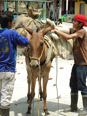
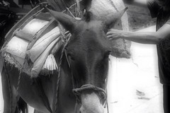
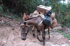
We arrive at noon and are served lunch at the town. They pack up the burrows with our supplies, but we carry our own packs. We have clothes and towels and toiletries for the five days we will spend in the rain forest.


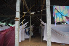
 The trail starts off rather easy, following a mountain river. We cross the river and start the climb up the first mountain. It is a steep climb and we realize how little cardio exercise we get on the boat. The first day is the toughest, but the trail is wide and the views are fantastic.We get to the first camp at about 5:30 pm, a little sweaty and exhausted. The last of our group arrived two hours later. Tonight we sleep in hammocks. After a brisk cold shower, we enjoy a cold beer and a hot dinner. It's the first time we have slept in hammocks so it takes a little while to get comfortable. It is also a communal style of living which the young backpackers are accustomed to, but it is a new experience for us.
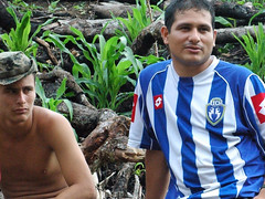
We have 15 in our group ranging in age from 21 to 54. I am the oldest. We are a pretty diverse group. Most of the others are on extended trips, staying in hostels and traveling around Central and South America. Quite a few also speak Spanish. We have a couple of guys from Paraguay, a couple from Germany and two guys from Colombia (one of which is American but has just moved to Colombia). Then there is a girl from Belgium, a girl from Sweden, a girl from Holland, a girl from Canada, a guy from France, a guy from Israel and a guy from Germany all traveling alone. I am really impressed by these young people who head out to explore the world often traveling on their own.


 As we head out on the second day the guys who arrived late to camp took an hour head start. The trail leads us through beautiful mountain pastures, past cows grazing, Kogi dwellings, banana plantations and across numerous streams and waterfalls. The Kogi are the indigenous people living in this part of the Sierra Nevada. There are about 70 families living in this area. We meet them along the trail and they often show up at our camps to visit. The guides know them all and they offer them bread and sweets, often exchanging it for bananas or other fruit. You cannot take to take photos of them without permission. They are very short, probably no more than four feet tall. They all have long black hair, men and women, and wear traditional clothes. The women are barefoot while the men wear rubber boots.
 Continued in next installment...
The Sierra Nevada mountain range are the highest coastal mountains in the world and is the home of the indigenous Tairona people who built the city consisting of stone terraces and complex paths and stairs during the 11th century. This is now known as the Lost City or Ciudad Perdida. The Sierra Nevada Park opened the Ciudad Perdida site to the public in 1981. The trek there and back is about 48 kilometers and the trail starts at the mountain town of el Mamey, also known as Machete Pelao. This is at about 250m elevation and a three hour drive from Santa Marta.
We arrive at noon and are served lunch at the town. They pack up the burrows with our supplies, but we carry our own packs. We have clothes and towels and toiletries for the five days we will spend in the rain forest.
We have 15 in our group ranging in age from 21 to 54. I am the oldest. We are a pretty diverse group. Most of the others are on extended trips, staying in hostels and traveling around Central and South America. Quite a few also speak Spanish. We have a couple of guys from Paraguay, a couple from Germany and two guys from Colombia (one of which is American but has just moved to Colombia). Then there is a girl from Belgium, a girl from Sweden, a girl from Holland, a girl from Canada, a guy from France, a guy from Israel and a guy from Germany all traveling alone. I am really impressed by these young people who head out to explore the world often traveling on their own.
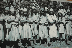
This is an old photo of the Tayrona people taken at the Gold Museum in Santa Marta.
Subscribe to:
Posts (Atom)